GPS轨迹数据集
2019-03-13 02:18阅读:
Please check my mail
on:
Sun, Mar 3, 2019
at:
my university mail, sina mail
on additional dataset information which is not allow to be pasted
here for so-called-shit sensitive words!
------------------------------------------
交通情况数据集
2017年11月22日 15:42:35 水野与小太郎
阅读数:5058
一、SanFrancisco Bay Area
1.数据集包括500辆出租车近30天的(2008年5月17日-6月10日)行驶数据
2.车辆行驶数据的采样时间间隔1min
3.车辆轨迹数据包含:车辆ID-经纬度(位置)-是否载客-时间
4.无瞬时速度
下载链接:
点击打开链接
二、Shanghai
1.数据集包括4千辆出租车24个小时(07年2月20日)的行驶数据
2.车辆行驶数据的采样时间间隔为1min
3.车辆轨迹数据包含:车辆ID-Time-经纬度-速度-是否载客
下载链接:
点击打开链接
三、Roma
1.数据集包括320辆出租车在罗马市区一个月(14年2月1日-3月2日)的行驶数据
2.车辆行驶数据采样时间间隔为7s
3.车辆轨迹数据包含:车辆ID-时间-经纬度
下载链接:
点击打开链接
四、France
1.数据集为法国克雷泰伊的一个环形道路上早上两小时(7.00-9.00)和晚上两小时(17.00-19.00)的车辆行驶数据
2.数据采样时间间隔为1s
3.车辆轨迹数据包含:车辆ID-时间-车辆类型-坐标-车辆速度
下载链接:
点击打开链接
环形通道示意图:
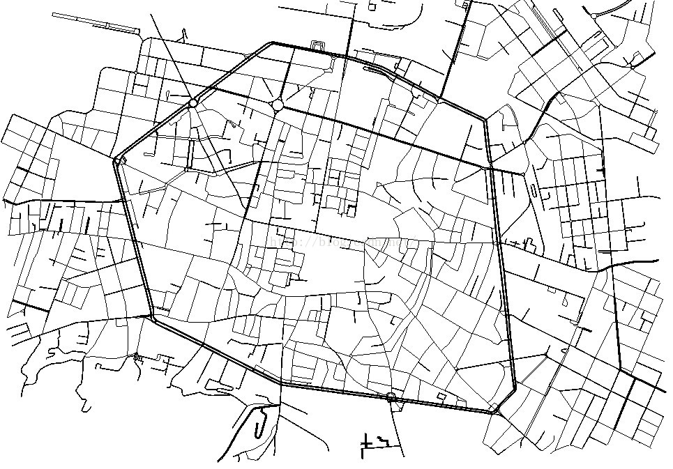
 五、Italy,Bologna
1.数据集为意大利博洛尼亚地区某个工作日早上8.00-9.00超过22000辆车的车辆行驶数据
2.数据采样时间间隔为1s
3.车辆轨迹数据包括:时间-车辆ID-经纬度-速度
下载链接:
点击打开链接
博洛尼亚地区道路示意图:
 六、Spain,Madrid
1.数据集为西班牙马德里附近的两条高速公路(A6和M40)上一个工作日的上午8.30-9.00和11.30-12.00的车辆行驶数据
2.数据集中每辆车每经过500米会有一条数据记录
下载链接:
点击打开链接
七、California
1.数据集为
加利福尼亚两条高速公路上不同交通密度的车辆行驶数据
2.数据采样时间间隔为1s
3.车辆轨迹数据包含:时间-车辆ID-经纬度-速度
下载链接:
点击打开链接
八、Luxembourg
1.数据集为卢森堡2200平方公里地区某个工作日11小时的车辆行驶数据
2.数据采样时间间隔为1s
3.车辆轨迹数据包含:时间-车辆ID-经纬度-速度
下载链接:
点击打开链接
卢森堡地区道路示意图:
 九、Germany,Cologne
1.数据集为
德国科隆400平方公里地区某个工作日上午6.00-8.00的车辆行驶数据
2.数据采样时间间隔为1s
3.车辆轨迹数据包含:时间-车辆ID-经纬度-速度
下载链接:
点击打开链接
澳洲的LiDAR公开数据,已经做过标记
--------------
1.
Microsfot Research Asia: (200M)
Geolife GPS trajectory dataset – User
Guid
This dataset contains 17,621
trajectories with a total distance of 1,251,654 kilometers and a
total duration of 48,203 hours.
https://www.microsoft.com/en-us/research/publication/geolife-gps-trajectory-dataset-user-guide/
2.
University of California, Ivrine
GPS Trajectories Data
Set
https://archive.ics.uci.edu/ml/datasets/GPS+Trajectories
3,
https://www.cs.uic.edu/~boxu/mp2p/gps_data.html
The trajectory data provided below
is obtained from the GPS reading systems carried by two of our lab
members during their daily commute for 6 months. Each trajectory
represents a continuous trip of a member in the Cook county and/or
the Dupage county of Illinois.
4. taxi driver trajectory of microsoft research asia(146M)
This is a sample of T-Drive trajectory
dataset that contains a one-week trajectories of 10,357 taxis. The
total number of points in this dataset is about 15 million and the
total distance of the trajectories reaches 9 million
kilometers.
https://www.microsoft.com/en-us/research/publication/t-drive-trajectory-data-sample/?from=http://research.microsoft.com/apps/pubs/?id=152883
5.
Next Generation Simulation (NGSIM) Vehicle
Trajectories and Supporting Data - more than 800M
Researchers for the Next Generation Simulation (NGSIM)
program collected detailed vehicle trajectory data on southbound US
101 and Lankershim Boulevard in Los Angeles, CA, eastbound I-80 in
Emeryville, CA and Peachtree Street in Atlanta, Georgia. Data was
collected through a network of synchronized digital video
cameras.NGVIDEO, a customized software application developed for
the NGSIM program, transcribed the vehicle trajectory data from the
video. This vehicle trajectory data provided the precise location
of each vehicle within the study area every one-tenth of a second,
resulting in detailed lane positions and locations relative to
other vehicles. Click the 'Show More' button below to find
additional contextual data and metadata for this
dataset.
Downloads & Resources
==========
The coppe-ufrj/RioBuses dataset (v.
2018-03-19)
Dataset of mobility traces of buses in Rio de Janeiro,
Brasil
Contributed by Daniel Dias, Luís Henrique Maciel Kosmalski
Costa.
Real-time position data reported by buses, updated every minute,
from the city of Rio de Janeiro, Brazil. The file is CSV,
containing the date, time(24h format), bus ID, bus line, latitude,
longitude and speed of more than 12,000 buses.
This dataset has been downloaded 0 times, and cited
0
times.


